
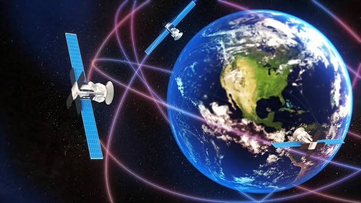
GNSS stands for Global Navigation Satellite System — the collective term for the satellite constellations that broadcast precise timing and positioning signals to receivers anywhere on Earth. When people say “GPS,” they usually mean GNSS as a whole, but GPS is only one of several systems.
GNSS vs GPS: What’s the difference?
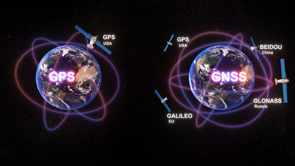
GPS (Global Positioning System) is the U.S. constellation. GNSS includes GPS plus Russia’s GLONASS, the EU’s Galileo, and China’s BeiDou, as well as regional systems like India’s NavIC and Japan’s QZSS. Using multiple constellations simultaneously gives a receiver more visible satellites, faster fixes, and better resistance to obstruction.
| System | Operator | Orbits | Signals used |
|---|---|---|---|
| GPS | United States | ~24+ MEO | L1 / L2 / L5 |
| GLONASS | Russia | ~24 MEO | G1 / G2 / G3 |
| Galileo | EU | ~24 MEO | E1 / E5 / E6 |
| BeiDou (BDS) | China | ~30 MEO + GEO | B1 / B2 / B3 |
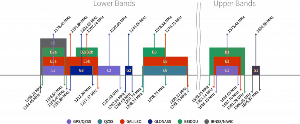
A Closer Look at the Four Global GNSS Systems
Global Positioning System (GPS)
Operated by the U.S. Space Force, GPS is the only system that has achieved global, continuous, all‑weather coverage with a long‑term service stability certification from bodies such as the International Civil Aviation Organization (ICAO). Its space segment currently consists of approximately 31 operational satellites in Medium Earth Orbit (MEO) at an altitude of about 20,200 km.
Modernized GPS satellites (Block IIF and III) fully support three civil frequencies: L1 C/A, L2C, and L5, with the L5 band specifically designed for aviation safety, offering enhanced resistance to multipath and interference. The primary advantage of GPS lies in its role as a de facto global baseline—almost all commercial receivers prioritize tracking it. Its limitation is that the standard positioning service (SPS) accuracy (horizontal ~4 m, vertical ~8 m, 95% confidence) can be affected by signal weakness; despite the permanent deactivation of Selective Availability (SA), GPS signals remain relatively weak and are prone to loss of lock indoors or in deep urban canyons.
GLONASS
Managed by the Russian State Space Corporation (Roscosmos), GLONASS currently has about 24 operational satellites in MEO at roughly 19,100 km altitude, with an orbital inclination of 64.8°. This high inclination gives GLONASS a distinct advantage at high latitudes (above 60°N), such as in Scandinavia, Siberia, and the Canadian Arctic Archipelago, where satellite visibility is significantly better than that of GPS and Galileo.
Unlike other systems that use Code Division Multiple Access (CDMA), GLONASS employs Frequency Division Multiple Access (FDMA) on its L1 and L2 bands—each satellite transmits on a different frequency. This design theoretically provides better resistance to narrowband interference. However, the FDMA architecture also increases receiver front‑end complexity and power consumption. In addition, GLONASS’s rubidium atomic clocks have slightly lower frequency stability than GPS’s cesium clocks, leading to marginally reduced long‑term timing accuracy.
Galileo
Galileo is a global civil navigation system led by the European Union (ESA and the European Commission). It currently has about 24 operational Full Operational Capability (FOC) satellites in MEO at an altitude of approximately 23,222 km, slightly higher than GPS. Its most distinctive feature is being the first system to offer a free global High Accuracy Service (HAS) —through the E6 band, it broadcasts correction data that enable real‑time horizontal positioning accuracy of about 20 cm (with a HAS‑capable receiver), without the need for ground differential stations. Galileo’s signal design is among the most modern: the E1 band is interoperable with GPS L1, while E5a and E5b provide wideband AltBOC modulation with excellent multipath suppression.
The system is fully controlled by civilian authorities, eliminating potential military intervention in service provision. However, Galileo’s deployment suffered multiple delays, and between 2016 and 2017, several satellites experienced premature rubidium clock failures. Although backup measures have mitigated the issue, these early reliability concerns have left some controversy regarding the system’s maturity record.
BeiDou Navigation Satellite System (BDS)
Operated by the China Satellite Navigation Office, BDS is the only global system that employs a hybrid orbital constellation—comprising approximately 24 MEO satellites (at ~21,500 km), 3 Inclined Geosynchronous Orbit (IGSO) satellites, and 3 Geostationary Earth Orbit (GEO) satellites, totaling about 30 operational spacecraft. This design gives BDS a notable advantage in the Asia‑Pacific region (70°E–140°E, 5°N–55°N), where the number of visible satellites typically reaches 12–16, far exceeding GPS’s 6–10, and regional positioning accuracy can be better than 2.5 m (horizontal, 95%). Moreover, the GEO satellites carry a unique short‑message communication function—not available in other GNSS systems—allowing users to send text messages of up to about 1,000 Chinese characters (with dedicated terminals) in areas without terrestrial mobile coverage, which is invaluable for maritime, desert, and emergency response scenarios.
On the other hand, BDS has a less dense global ground tracking station network compared to GPS and Galileo, which slightly reduces orbit determination accuracy in regions far from the Asia‑Pacific, such as South America and central‑western Africa. As a result, while BDS’s global average positioning accuracy (about 2.5–4 m horizontal) is comparable to GPS, its performance consistency in those edge areas is not yet as mature as GPS’s.
GPS in Context: The Baseline That All Others Measure Against
As the first fully operational global navigation system, GPS set the technical and operational standards that subsequent systems have followed. Its L1 C/A signal remains the most widely tracked civilian code, and its Coordinated Universal Time (UTC) dissemination via the U.S. Naval Observatory serves as a primary time reference for countless applications. While newer systems have introduced advanced features — such as Galileo’s HAS or BeiDou’s short-message capability — GPS retains its position as the indispensable backbone of the GNSS ecosystem, simply because it is universally supported by every commercial receiver and trusted by decades of uninterrupted service. At the same time, its aging infrastructure (though continuously modernized) and reliance on a single military operator mean that, for many critical users, GPS alone is no longer sufficient — hence the growing reliance on multi-constellation receivers.
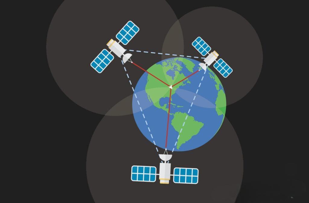
How GNSS provides Position, Navigation & Timing (PNT)
Each satellite carries an atomic clock and transmits its position and time. A receiver measures the time-of-flight of signals from at least four satellites and trilaterates its own position. The same precise timing also drives PNT for power grids, telecom networks, and financial systems.
Why GNSS signals are vulnerable
Civil GNSS signals arrive at the ground at roughly −130 dBm — far weaker than noise. That makes them easy to disrupt with jamming or spoofing. Assured PNT therefore depends on anti-jam antennas and signal-resilience technology.
Choosing a GNSS receiver
Modern receivers track multiple constellations and bands (including L5/E5/B2 for improved accuracy). For contested or safety-critical environments, pair the receiver with CRPA antenna technology that can null interference. See our GNSS frequency bands guide for band details.
Related: GPS vs GLONASS vs Galileo compared · How GNSS anti-jamming works.